Gangway To Heaven

He bowed with hands clasped. My hands were clasped too after swatting one of the many mosquitoes buzzing around us.

Under the darkness of the rainforest canopy, surrounded by bamboo and wild rubber trees, was a mysterious, twisting gangway that goes further uphill. Up it, the two of us went.

My sherpa was really helpful. He held me by the collar when I leaned over too much at a ravine to take pictures. At slippery narrow stretches, he lead me by holding my hand, Instagram lover-style. At steep gradients, he dragged me up the mountain Hillary-style.

Sony Alpha a7R, ISO 16000, f4, 1/500 sec.

It’s A Jungle Out There

The inhabitants here are of the Temuan tribe and indeed there is a dog at every turn. Aboriginal dogs were originally kept as hunting dogs and were lean and mean.

Acting also as guard dogs for those staying deep in the jungles, they alert human companions to approaching wild boars, bears and other aggressive wildlife. Importantly, they provide endless fun and companionship for Orang Asli children growing up without toys, gadgets and electricity.

Here at this village, the dogs are mostly lethargic and sleep in the middle of the road. So do be very careful if you drive through the village.

I was enchanted by the rustic settings and asked a village elder if there is some kind of homestay hut. Although he speaks impeccable English, just like the aboriginal character in Crocodile Dundee, he didn’t understand the term ‘homestay’. I mentioned ‘hotel’ and he smiled.

Me, him and the dog ended up hiking up a steep jungle trail. Panting under the weight of my equipment, I stopped him to ask if this mysterious, fabled jungle place has a porter to help with my luggage.

Not surprisingly, he said “No!”. But then he added: “They have a Nepalese sherpa”. Haha. What unfolded next is mind-blowing.

Sony Alpha a7R, ISO 125, f4, 1/500 sec.

The Seven Holes Of Serendah

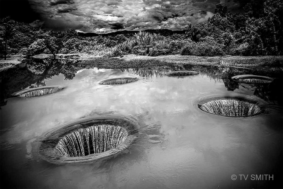
The holes were located in a lonely but beautiful park in Serendah. Not sure if it was the threatening rain clouds or the mystery of the holes that made everything there very eerie.

Since the sink hole strainers are missing, do I dive into one of the ‘rabbit holes’ and will it take me to Wonderland? Apparently not; as further investigation revealed the water flowing into underground channels and released, like sewer, a little further down the cascaded river.

The place was very deserted at the time I was there and there was no one around to ask for info. Oddly, there were no information signboards, even though it is billed as a tourism attraction.

I found out two versions of its history and reason for existence from nearby villagers (subsequently). Originally, there were natural whirlpools in the river .

For some safety or silly reasons, a crazy British colonial administrator flattened the river and turned it into this bizarre man-made structure. It was called The Seven Wells of Serendah (Perigi Tujuh) .

Another local told me a more plausible but less romantic story. Serendah is named as such because it is very low-lying (rendah). It was also a tin mining area with many water canals.

Every time it rained in those days, the surrounding villages became flooded quickly as the river and canals overflow. The seven wells and water channels acted as part of a stormwater management system.

It is so hidden, isolated, relaxing and peaceful here, one will find many ‘ponteng” school students ‘lepaking’ here.

Sony Alpha a7R, ISO 100, f4, 1/1250 sec.

W Is For Waterfall

Not since Chamang Falls, have I seen a massive, roaring waterfall so accessible. One can literally drive to the edge of its drop pool. Unlike the one in Bentong, this Serandah drive-in waterfall is not far from the main road.

Photography Notes: Without ND filters and a tripod, I opted for the opposite end of the speed spectrum. Instead of using a slow shutter for a silky effect. I used a fast shutter to crystallise the droplets and spray.

Sony Alpha a7R, ISO 2500, f4, 1/8000 sec.

The Journey Begins

This is the start of a new photo essay on the first interstate main road of Malaysia; the Federal Route 1. It spans over 800 kilometers, beginning at the border with Singapore, and ending at the border with Thailand. Constructed in stages from around 1909, it was the backbone of Peninsular of Malaysia until it was supplanted by the newer North-South Expressway in the 1980s and 1990s.

I hope to visit some of the landmarks and towns along the old route and record the many long lasting effects on the landscape. While the impact may not be as severe as the decay of the famous and longer Route 66 of America, little is documented of the decline of the many once-bustling towns on our historic Federal Route 1.

The journey north from KL to Ipoh used to begin at Bulatan Kuching. Travelers were soon greeted by a hilly and winding road into Templer’s Park. The Kanching Falls, along with pristine forests and streams were once popular attractions for KL residents. From Route 1, motorists can still see this landmark limestone and granite monolith that is part of Bukit Takun. It is now surrounded by gated housing and a golf course, though.

Next stop is the first stopover town of Rawang. Follow me on this fascinating journey.

Sony Alpha a7R, ISO 100, f11, 1/640 sec.